What is Soil Texture? Classification System of Soil Texture
What is Soil Texture?
The texture of the soil is an indication of the relative content of particles of various sizes in the soil. It will indicate the percentage of sand, silt, and clay present in the soil. Soil texture will influence the ease with which the soil can be worked. The texture of the soil is dependent on:
- Particle size distribution
- The shape of the particles
- Gradation of the particles
When the textural classification of soil is concerned, we only take into consideration the particle size distribution. The other two parameters are difficult to incorporate in this classification.
Textural Classification System
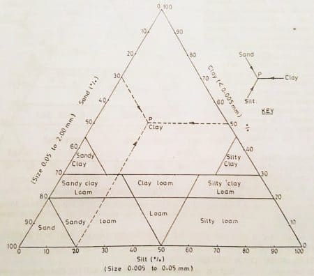
The US Bureau of Public Roads recommends triangular classification system for soil which is commonly called as the textural classification system. The figure- 1 below shows the textural classification system, where the three sides of the equilateral triangle represent the percentage of sand, silt and clay. Where the size of,
- Sand = 0.05 – 2mm
- Silt = 0.005 – 0.05mm
- Clay = size < 0.005mm

As shown above, the equilateral triangle has 10 zones. Each zone of the triangle will represent each type of soil. Hence, by determining the zone the type of soil can be classified. In order to locate the point a key is given. This key will give an indication about the direction at which the lines are to be drawn so that points can be located.
For example, as shown in the figure- 1, “P” is located corresponding to 30% sand, 50% clay and 20% slit. Now the point P will fall on the zone clay. Hence the soil is classified as clay.
Soils containing different constituents can be easily classified by the textural classification system. This classification system ensures no particles greater than 2mm size is present. In cases where a certain amount of particles greater than 2mm is present a correction is required. Here the percentage of sand, silt and clay is increased to 100%.
For example, if the soil sample contains 20% of particles that are greater than 2mm size, actual sum of sand silt and clay (%) = 80.If percentage of sand = 12, percentage of silt = 24, percentage of clay = 44. The Correction factor will be (100/80). Therefore, the corrected % would be 15, 30 and 55% respectively.
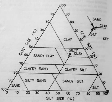
The term “loam” is encountered while working with the textural classification system. Loam is used to describe a mixture of sand, silt, and clay in various proportions. The term loam is not used in soil engineering and a modified triangular diagram was proposed by Mississippi river commission USA (Figure – 2).

Right triangle chart
In Right triangle chart, the two perpendicular sides will represent clay and silt percentage. As some of the percentages of sand, silt and clay will be 100%, It is not necessary to plot all the three. If clay and silt is represented in the right triangle
The percentage of sand particles = 100% – (sum of percentages of silt and clay).

From figure – 3, the lines of intersection of silt and clay will give the textural classification. The right triangle diagram is more convenient than a triangular diagram. The right triangle diagram consists of orthogonal lines which make the point location easy.

No comments:
Post a Comment